| Kingshouse to Kinlochleven | Back to West Highland Way index | Fort William to Gairlochy |
| Kingshouse to Kinlochleven | Back to West Highland Way index | Fort William to Gairlochy |
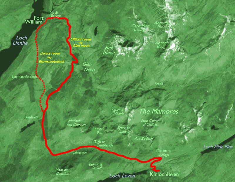
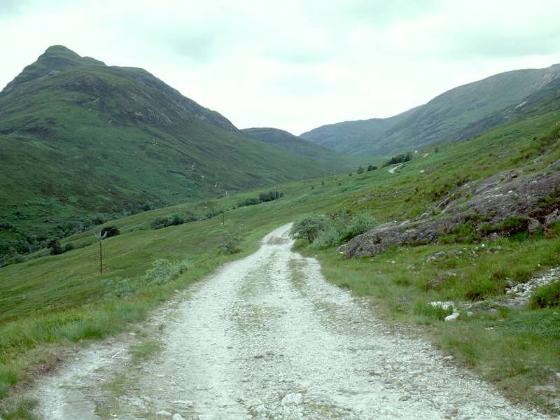
This section of the Way makes use of an old military road, part of the network built by General Caulfield, and one that eschews the sea level route along by Loch Leven and Loch Linnhe. This road rose away from Kinlochleven to follow the valley of the Allt Nathrach (stream of the snake) up to the Lairig Moire, or Great Pass, and thenceforth followed the Allt na Lairige Moire to the summer pasture country of Loch Lunn Da-Bhra, and finally over a low ridge of moorland to what was then the garrison town of Fort William. The old road is now a rough vehicle track, serving only the Mamore estate and the forest plantations around Blarmachfoldach. It does, however, give excellent and trouble free walking.
The pass runs hard around the southern edge of the Mamores, specifically the peaks of Am Bodach, Sgurr an Iubhair, Stob Ban and Mullach nan Coirean. It's unfortunate, therefore, that the scenic grandeur of most of these fine hills is poorly displayed from this side. All you get, really, is an impression of vast bulk. There are stalkers' paths rising up to the summits and the cols but they are not always apparent from low down near the valley and a good map is necessary to locate them.
Apart from two ruined cottages near the summit of the pass there is little sign of the hand of man - excepting the track itself, of course - between Kinlochleven and Blarmachfoldach. You can be alone with your thoughts out here, with nothing but the hills, the streams and the pine trees for company. It's a reminder of how insignificant mankind is in the general scheme of things.
Despite the route being simple and straightforward it has three alternative starts and three alternative endings. From Kinlochleven there are three ways up to the route of the military road, of varying lengths and grades - you can choose a long, gentle ascent or a short steep one. At the far end, there is a choice of the direct route into Fort William via its southern suburb of Auchintore, the official route of the WHW over into Glen Nevis, or the link route between the two over the shoulder of Cow Hill. The direct route cuts a couple of miles off the route and might be preferred in bad weather or if you are weary or pushed for time.
Unless you're backpacking and therefore staying at Kinlochleven itself the key to this walk is the local bus service from Fort William, via Ballachulish and Glencoe crossroads. For those coming from the south the main connection point between Citylink coaches and the local bus services is at Ballachulish, though the connection arrangements and physical position of the halts has changed several times during the last few years and is terminally confusing. Unless you're coming from Oban the safest bet is to change buses at Glencoe.
|
|
|
| Length: | 16 miles / 25.8 km |
| Total ascent: | 2604 ft / 794 m |
| Total descent: | 2613 ft / 796 m |
| Estimated time: | 5 hrs 58 mins |
Map: OS 1:25000 Explorer 392 (Ben Nevis)
The official route of the West Highland Way is the most straightforward option out of town, though there are both short/steep and long/gentle alternatives. All three options involve leaving the town centre along the road through town to the north, which after about 500 meters from the river bridge turns left (west) to run along the north side of Loch Leven. The official route of the WHW is the first path off to the right, about 300 meters to the west just opposite the school. This path rises diagonally through open woodland and rough grassland, slanting up to the northwest. After about 500 meters it crosses the rising track of the estate road to Mamore Lodge and then continues, for a further 600 meters, before merging with the old military road up to Lairig Mhor.
The second option is of course the Mamore Lodge road itself, which is the longest but gentlest climb. This road leaves the main motor road about a kilometre west of town and rises north-eastwards across the slope, crossing the northwest trend of the WHW footpath after some 600 meters and continuing for another kilometre to Mamore Lodge. Here you turn hard left for the military road along the Allt Nathrach.
Your final option is a local footpath that rises away from the main road about 150m further west than the Mamore Lodge driveway. This path rises up the same slopes of open woodland but more directly and steeply, before tending north-eastwards to merge with the WHW footpath, onto which you turn left.


Riverside path in Kinlochleven; the road out of town near the school
My preferred option is to take the local riverside path initially, which comes out on the main road not far short of the school, then to take the official WHW path from the school as far as the Mamore Lodge road, then to turn right and follow this road to the lodge and walk the whole length of the old military road. I favour this route because it gives some splendid views of Loch Leven itself, which are missed if you take the official route. Besides, Mamore Lodge has a cafeteria.


The WHW ascending from the school; Kinlochleven from Mamore Lodge road; Mamore Lodge road


Road end at Mamore Lodge; the Caulfield military road to Lairigmor


Loch Leven from the TV mast; Kinlochleven from the same point
The track continues westwards and shortly afterwards the official WHW footpath converges from the left, just at the point at which the view of Loch Leven is cut off by the rising slopes of Beinn na Caillich, the hill that stands on the north side of the loch. From here our route runs along the north side of the Allt Nathrach (stream of the snake), which disappears up into an intriguing little valley hemmed in between Beinn na Caillich to the south and Stob Coire na h-Eirghe, an outlier of Sgurr an Iubhair, to the north.


Approaching Beinn na Caillich; The official WHW merges from the left; Gleann Nathrach
Little changes within the next two miles. You pass the Coire a Bhutha to your right, which separates Sgurr an Iubhair from Stob Ban (arguably the most pleasing of the Mamores, with its pyramid-shaped quartzite peak). On the other side, the Fraoch Choire wanders off south-eastwards up to the summit ridge of Beinn na Caillich.

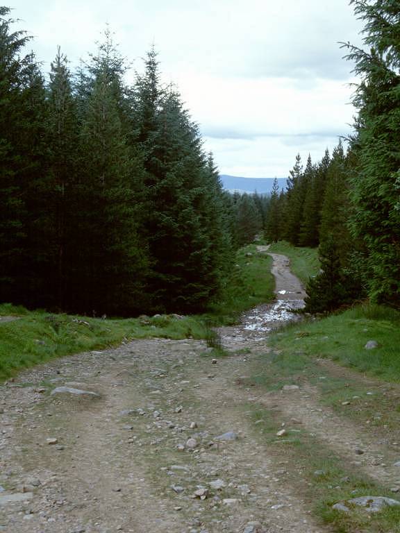
The track to Lairig Mhor, looking forwards and backwards


The West Highland Way in Gleann Nathrach, and Stob Ban from the south


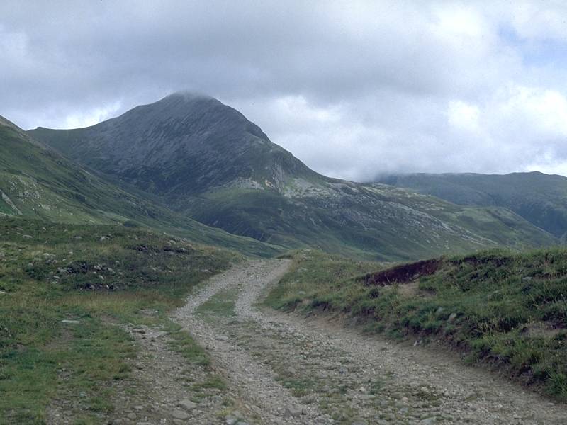
Further along, pretty much at the summit of the pass, you reach Tigh na Sleubhaich, the first of two ruined cottages alongside the trail. From here the Coire na Sleubhaich rises steeply north-eastwards to the complex Mamore ridge west of Stob Ban, providing one of the day's best views. The roof of the cottage itself is long gone but a lean-to on the western side is roofed and appears to be used as a bothy.


The WHW at Tigh na Sleubhaich; Tigh na Sleubhaich and Stob Ban
Don't forget to look up unto the imposing Coire na Sleubhaich to the northeast as you pass the cottage, for there is an awesome view of the quartzite summit of Stob Ban. There's a ghost of a path visible on the summit ridge, though none lower down.


The WHW west of Tigh na Sleubhaich
The WHW crosses the stream issuing from the Coire nan Sleubhaich on a gaunt but effective concrete slab bridge, and begins to descend from the summit of the pass. In just over a mile the second ruined cottage, that of Lairgmor, is reached. Lairgmor is in far worse repair than its neighbour and is mostly rubble. A prominent stalkers' path rises south of Lairgmor, heading for a col west of the summit of Mam nan Gualainn to the southwest.


The path to Mam nan Gualainn; The ruin of Lairgmor cottage; looking back at Stob Ban


Reaching the shoulder of Meall a Chaorainn
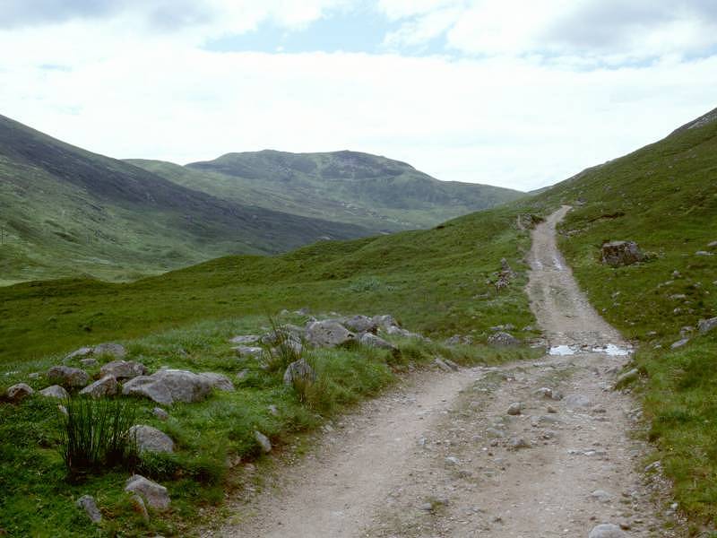
The path runs on past Lairgmor for another mile, running along the north side of the rapidly developing Allt na Lairig Moire (stream of the great pass). The valley approaches a turn to the northwest and the path abruptly turns right, running almost straight for about a mile as it rises again to cross the shoulder of the Meall a Chaorainn (the southwest outlier of Mullach nan Coirean, the westernmost Munro of the Mamores).


The path rounding Meall a Chaorainn, and looking left into Coire Dhuibh
As the path starts to descend again you see a softer, more open landscape spread out ahead of you. The lonely Coire Dhuibh (black corrie) sweeps away to the southwest. Just after a mile from the great right-hand bend in the path the first of the Lundavra forest plantations is reached .


Looking back at Mam na Gualainn; Coire Dhuibh; reaching the Lundavra forest plantation
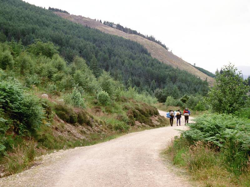
The forest stretch continues for about a mile and a half. At the northern end of the forest section you reach the locality of Lundavra.


The West Highland Way through Lundavra forest.


The WHW diverging to the right at Lundavra; the end of the motor road
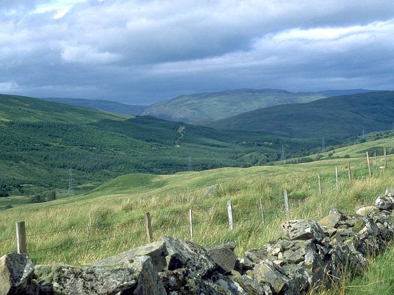
As you emerge from the northern end of the forest the track forks into two options. The left path descends to reach the end of the motor road from Fort William about 100 metres ahead, while the path to the right is the official West Highland Way and is the route into Glen Nevis. From the route marker board (seen in the first picture above) you get a grand view down across Lundavra and Blarmachfoldach, with Loch Lunn da Bhra just visible over to the west.
This is decision time. The official route via Glen Nevis strikes off slightly east of north, through forest plantations into a nameless glen south of Bidhein Bad na h-Ioaire before climbing over the col into Glen Nevis. The direct route is described below.


Diverging routes at Lundavra; forest path; Loch Lunn da Bhra
From the route marker where the direct and official routes diverge, follow the official route through another limb of the forest plantation, climbing fairly steadily. After some 500m the path comes out onto a ridge of moorland and follows a remarkably straight course. Initially there are views westwards to Loch Lunn da Bhra before the path settles onto the east slopes of a low ridge to cross an area of open moorland. The hill of Bidhein Bad na h-Iolare lays about two miles ahead of you, with extensive forest plantations cloaking its southern slopes. Our route is going to work its way through those plantations and up to the col to the northeast.


The path crossing the open moorland section, with Bidhein Bad na h-Iolare seen ahead
At the far end of the open moorland section the path re-enters forest and, after a few minutes, drops to cross a pleasant mountain stream (the Allt Coire a Mhuilinn) by a footbridge. It's a pleasant little dell and is the first of many. The general route of the path kinks to the right after the stream. After a further 800m you briefly come out into the open again before entering the main bulk of the forest.


The second section of forest
Once you're into the main section of forest the path starts to play tricks on you. This section seems interminable and, since you don't have any views over the surrounding countryside, you're unable to judge distance. A decent straight stretch rewards you with a pretty fine view of Ben Nevis dead ahead, after which is starts to twist and turn and rise and fall somewhat. Now the fun starts. You descend quite steeply to a dell through which a substantial stream thunders down to your left, and afterwards the path climbs steeply away again. Are you near the col? No. That was a feeder stream of the Allt nan Gleann. There are several more to come. The path winds through the trees for what seems like miles before dropping down a steep slope to reach yet another stream, but after climbing out again resumes its general upward trend. Another long distance trek, then another change of scene and a steep drop through a dark mass of trees. Surely this must be the initial drop into Glen Nevis? No, it isn't. You pass the massive rock seen in the middle picture below and climb steeply onwards. Trees. Trees.


View of Ben Nevis; massive boulder by stream crossing; more trees
After another interminable length of forest the path suddenly bursts into an open area and snakes downwards to cross a magnificent river that cascades down from a miniature ravine, seen up to your right. This must be Glen Nevis now, surely?
No.


Perhaps the cruellest part is yet to come, for you are sure you must be close to the col now, but the path climbs yet more steadily and begins to twist and turn among the trees. There are no more big streams to cross, just a couple of minor ones, and you occasionally glimpse running water down to your left but you are unable to see which way it flows. You begin to long for the moment when the water flows forwards, down into Glen Nevis. It's probably some twenty or thirty minutes beyond that last big ravine, for half of which time you keep thinking that surely this bloody path can't just keep toiling uphill, when suddenly the scene in the second image above opens up ahead of you. There's a sign to the viewpoint and ancient fort of An Dun (don't go that way!), and ahead of you is Meall an t-Suidhe, the north-eastern outlier of Ben Nevis. Turn left and begin the descent into Glen Nevis at last.


The forest path from An Dun down to Glen Nevis
Once you're on the forest road system continue north for about 1.5 km. Various options exist for dropping down to the road once you meet the junction of tracks. For Fort William direct turn left and continue to follow the track northwards. For Glen Nevis (the youth hostel, campsite or cafe/restaurant), dogleg to the right (third image below) and walk a short distance until you reach a side path to the left. Follow this path, which snakes down the last part of the slope and then crosses the pastures on the east side of the glen before coming out directly behind the cafe/restaurant. This establishment is a godsend to thirsty hikers (it has a bar as well) but be sure to take off your boots and pack before going in. If you left Kinlochleven much after ten thirty you may be too late for that pot of tea you've promised yourself, as the evening menu may have kicked in. For the youth hostel go right (south) along the glen for about 300m; for the camp and caravan site and for Fort William go left. It's about two more miles to Fort William from this point.


Forest track; view over felled area to lower Glen Nevis; route to glen and youth hostel
The West Highland Way's official route drops down to the roadside at the point where the track from Cow Hill and Auchintore joins from the west. There is an option to continue along the forest ride if you wish, otherwise follow the track down to the Braveheart car park (oh dear!) and thence to the main road along the glen.


The last section of the forest ride
About a mile and a quarter north of the youth hostel all possible routes join the road, which now curves around to the northwest out of the mouth of the glen. The so-called Lower Falls of the river Nevis provide a pleasant few minutes' diversion The road now curves left, or west, through tree cover to come out at the northern end of Fort William near Inverlochy. A sign outside the woollen mill at the Nevis Bank roundabout proclaims the official end of the West Highland Way; Fort William itself lays about ten minutes' walk to the south.


Lower Glen Nevis; approaching Fort William; the end of the WHW

The direct route into Fort William follows the road from Lundavra all the way down into town, a distance of some four miles. The road follows the short valley of the river Kiachnish through the scattered and rather isolated community of Blarmachfoldach.
The Kiachnish river makes its own way down a steep westwards drop to Loch Linnhe. The road continues, over a surprisingly bleak stretch of moorland, before beginning the shallow descent to upper Auchintore, the southernmost extremity of Fort William. Views of the vast bulk of Ben Nevis begin to open out to the east but the summit is not seen from this aspect.
All at once a steeper downward slope is breasted and the first houses of Auchintore appear a few hundred yards ahead. As the houses are reached a vehicle track branches off to the east; this serves the town's TV relay on Cow Hill and from it a simple footpath leads down into Glen Nevis, providing a third (though inelegant) alternative to the last few miles of the west Highland Way.
One failing of the town is that it has relatively few places to eat out for a reasonable price. The cafes attached to the Safeway supermarket and the Nevisport store, both near the railway station at the north end of town, are the best bet - both close relatively early, however. Even McTavish's Kitchen stops serving before most walkers have had a chance to shower and change, so you're left with a choice of the chippy, the Macdonalds or a high-priced hotel restaurant. I've learned exactly where Safeway keeps the pot pasta and the tubs of dessert rice - self catering is quick and cheap!
Fort William has trains to Glasgow and Mallaig, and the Citylink coach services to Glasgow (via Glencoe and Crianlarich), Oban, Inverness, and Kintail and Skye. A seasonal bus service operates two or three times daily to Aviemore, and there are also local services into Glen Nevis (for the youth hostel) and to the Nevis Range gondola lift on Aonach Mor.
![]() Train
times from Fort William (.pdf document)
Train
times from Fort William (.pdf document)
![]() Citylink
bus connections at Fort William: Glasgow-Ft
William,Oban-Ft
William-Inverness,Edinburgh
- Ft William (.pdf documents).
Citylink
bus connections at Fort William: Glasgow-Ft
William,Oban-Ft
William-Inverness,Edinburgh
- Ft William (.pdf documents).
| Kingshouse to Kinlochleven | Back to West Highland Way index | Fort William to Gairlochy |
This page last updated 7th February 2005
![]()