| Winchburgh to Linlithgow | Back to South of Scotland Way index | Falkirk to Croy |
| Winchburgh to Linlithgow | Back to South of Scotland Way index | Falkirk to Croy |
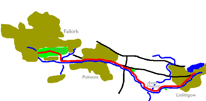
The last two miles of this section involve
a detour away from the canal through the woodlands of Callendar Park,
southeast
of Falkirk itself. The route emerges from the park at Falkirk's
Slamannan
Road, very handy for Falkirk High railway station which lies just two
hundred
meters to the west.
Maps: OS 1:25000 Explorer 349 (Falkirk)
Click
on
any thumbnail image in this gallery to display the corresponding full
size
image. The images are access protected through a cgi script to prevent
hotlinking. If you encounter problems while trying to view the full
size
images, please read the access advice
page.


Leaving Linlithgow alongside the canal; Linlithgow and a distant view of the Stirlingshire hills
![]() Scotrail
timetable (Acrobat pdf file) for Edinburgh - Linlithgow - Falkirk -
Glasgow
services
Scotrail
timetable (Acrobat pdf file) for Edinburgh - Linlithgow - Falkirk -
Glasgow
services
The directions couldn't be simpler. Assuming you're starting from Linlithgow railway station, take the nearest underbridge to the west of the station and cross to the south of the line, then find the road heading up to the slip off the canal towpath, adjacent to the canal museum. Turn right onto the towpath on the north side of the canal, and start walking.
You first pass through the western environs of Linlithgow itself, a mixture of the old and new. Over to the right you can't fail to notice a complex of modern buildings that form Linlithgow academy; beyond them, on a clear day, is the uplifting sight of the hills bordering Stirlingshire and Perthshire, such as Ben Ledi and Ben Vorlich.


Rural scenery west of Linlithgow


The town eventually falls away and there follows a couple of kilometres of pleasing rural scenery. The canal meanders a little, which serves to present you with constant and pleasing changes of vista every few hundred meters. The locality of Kettlestoun Mains lies over to the right and Kettlestoun Lower Wood is just to the left. A long curve to the left leads you through Woodcockdale, after which the canal begins to curve back to the right and approaches the Avon valley.


The Avon marks the boundary between West Lothian and the District of Falkirk, and is crossed by the Avon Viaduct - the largest original civil engineering structure on the Union canal. The viaduct is of 23 arches, has a maximum height of 85 ft and is almost 900 feet long. (It is now dwarfed in stature by the new Falkirk Wheel, which was opened in the summer of 2002). The views into the Avon vale itself from the viaduct are both pleasing and impressive.
It should be noted that this particular River Avon is but one of several in Britain, and in fact "Avon" is probably our commonest river name. It's perhaps explained by the fact that Avon is a corruption of the Gaelic word "Abhainn", which itself translates as "river". What we have here, effectively, is the River River.

The canal near Almond
Beyond the viaduct the canal puts in a fairly tight right-hand curve and ends up heading almost to the north, before swinging sharply to the west once again near a locality called Almond. The general scenery around here is pretty rural though there are still middle-distance vistas of industrial estates, quarries, power lines and motorways.


The canal in the vicinity of Haining valley
For the next mile or so the canal tracks generally north-westwards. To the north lies Haining Valley, Haining Wood and Almond Castle as well as a large industrial site. A little further on, The Haining lies to the south, with the village of Maddiston beyond. We're beginning to lose the view of the Ochil Hills to the north, but the Kilsyth Hills (and the Campsie Fells beyond) are now beginning to appear to the northwest. Ben Ledi, northwest of Callander and about 30 miles away, is prominent in the distance.


Picnic site on the south bank; scenes between Haining and Polmont
Early in this stretch - I regret that I am unable to remember the particular locality - one of the overbridges gives access to a small picnic site on the other bank. This patch of greenery represents about the only opportunity for a decent refreshment break so don't pass it by. After you pass Haining Wood on the north side the canal passes beneath a modern flyover carrying a spur from the M9 to the Bowhouse roundabout south of Maddiston, and shortly afterwards it crosses over an unclassified road at Bethankie Bridge. You draw close to the railway again and in another 800 meters you pass Battock (a single building, presumably a farm). Beyond Battock the canal curves smartly to the left to head due west as it enters the town of Polmont.


Hamish Brown, in his book about the Union and Forth-Clyde canals, is rather dismissive of Polmont; there is rubbish tipped into the canal, he tells us, the bridges and walls are disfigured with graffiti, and the bridges themselves carry eyesores such as sewer pipes slung across their outer walls. In fact I found that Polmont passes by almost without notice. There is no need to leave the canal towpath, except if you specifically want to look at the town, or to break your journey at its railway station. Since the canal is in a fairly deep cutting through the town you don't really notice much except the banks, which in any case have an extensive cover of vegetation.
![]() Scotrail
timetable (Acrobat pdf file) for Edinburgh - Polmont - Falkirk -
Glasgow
services
Scotrail
timetable (Acrobat pdf file) for Edinburgh - Polmont - Falkirk -
Glasgow
services


The canal on the west side of Polmont
Technically, Polmont lies to the north of the canal while the housing estates to the south constitute a separate town called Brightons. But you see little of either. Just past the main road bridge the canal enters a tight little curve to the right and ends up running almost north, then kinks very sharply left again to run almost due west. You pass a young offenders' prison on the left, a grim looking place surrounded by fences topped with barbed wire; following this is an open section, then finally you run into the edge of a small industrial estate (seen in the rightmost picture, above).


The Union canal west of Polmont; the turnoff for Callendar Park at Woodend
Once you are past the industrial estate you enter an area of towpath that is quite densely wooded, but there's not far to walk along this stretch before you take a right turn, at Woodend on the eastern outskirts of Hallglen, for a path that will lead you out onto a road and then into Callendar Park. You do, of course, have the option of staying with the canal towpath but be warned that there is a 630-metre tunnel to negotiate before you reach Falkirk High. The towpath is continuous through the tunnel and I am assured that there is a decent handrail, but if you want to take this option I would advise taking a torch. There is a third option, which involves taking the road northward along the outskirts of Glen Village; this avoids both Callendar park and the canal towpath and is therefore the least satisfying option of the three.

The path at Woodend
The path at Woodend is a little more complicated than would appear from the map; it runs for about 400 meters and involves crossing the railway line by an underbridge, and then crossing a stream via a footbridge. The path leads through dense tree cover but eventually opens out onto the minor road between Hallglen and Westquarter (a western outpost of Polmont). Follow this road eastwards for 200 meters then turn left (north) onto an obvious but unsigned driveway leading into a dense, walled woodland plantation. The entrance is daunting and there is no obvious indication that the public are welcome; nevertheless you have just entered Callendar Park.

Entering Callendar Park from Woodend


Scenes in Callendar Park
Callendar park is owned by Falkirk Council and is one of the town's primary leisure facilities. The park's centrepiece is Callendar House which is off our route, but could of course be visited if you wish. Our route through the park stays within extensive tree cover, which does make a nice contrast to countless miles of canal towpath walking.


The route through Callendar park
From the map there appears to be a bewildering maze of paths within the park, but in practice the correct route is easy to find. Just follow your nose and stay on what appears to be the main track. You will be led unerringly towards the big gates at the end of Slamannan Road, south of Falkirk town centre. The gates are usually closed but the park is easy enough to leave; just turn right (north) at a major path junction about 150m short of the gates themselves (first picture below), to find a viable exit, then turn left again and follow the road round the outside of the park perimeter until you reach the outside of the gates.

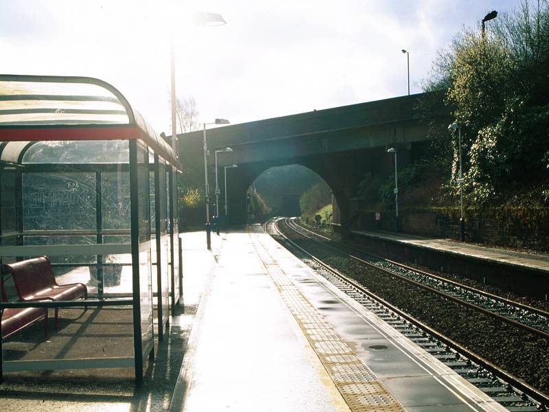
With your back to the gates, start walking along Slamannan Road. You don't have far to go. In about 200m you reach a flight of steps down to your right that gives direct access to the eastbound platform of Falkirk High station, on the direct line between Glasgow and Edinburgh and more or less equidistant from each.
![]() Scotrail
timetable (Acrobat pdf file) for Edinburgh - Falkirk - Glasgow services
Scotrail
timetable (Acrobat pdf file) for Edinburgh - Falkirk - Glasgow services
| Winchburgh to Linlithgow | Back to South of Scotland Way index | Falkirk to Croy |
This page last updated 19th April 2004
![]()