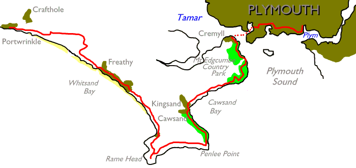
| Looe to Portwrinkle | Back to South Cornwall Coast Path index | Plymouth to Yealmpton |
|
|
|
| Length: | 15.5 miles / 24.84 km |
| Total ascent: | 3163 ft / 964 m |
| Total descent: | 3181 ft / 970 m |
| Estimated time: | 6 hrs 3 mins |
Map: OS 1:25000 Explorer 108 (Lower Tamar Valley & Plymouth)


Cawsand and its neighbour, Kingsand, are effectively one village. Up until the mid nineteenth century Cawsand was in Cornwall and Kingsand was in Devon; nobody seems to know quite why this was, and the only clue to the meeting point of the two is a little house named “Boundary Cottage” just short of the post office. Nowadays the county boundary follows the centre of the river Tamar and you will cross it in a couple of hour’s time on the ferry from Cremyll to Plymouth. These anomalous boundaries can and do persist for cenuries and even now you can find countless examples of district, county and even parliamentary boundaries that pass through the middle of houses for no apparent reason. But I digress.
The coast path deposits you in Cawsand at the southeast
corner of the main square. The main road into and out of the village
goes off
to the left (west); if you’re looking for the hourly bus back to
Plymouth from
here then walk along this road for a couple of hundred metres as far as
the junction
called the Cawsand Triangle, where you’ll find the bus stop. To the
right of
the square is a rudimentary harbour and beach, where you’l find the
Cawsand Bay
Hotel. An occasional passenger ferry runs to Plymouth from here during
the
summer and is probably quicker than the bus. The coast path runs up the
steep
lane at the northwest corner of the square, where a huge “No Entry”
sign is
painted on the road.


Cawsand and the harbour
Cawsand and Kingsand together form the last example of
Cornish “quart in a pint pot” architechture, in which cottages are
crammed and
shoehorned together among steep and narrow lanes. There is a real maze
of lanes
and alleys, but unfortunately the coast path is only waymarked once,
and so
discretely that the sign is all too easy to miss. When I came here in
the
summer of 2005 I got thoroughly lost three times in twenty minutes and
these
routefinding problems can be cumulatively annoying.


Cawsand Bay

From Cawsand into Kingsand
Firstly, when you reach the post office, go to your right
into what appears at first to be a back alley. It turns a corner to the
left
and runs along close by the waterfront, then
runs steeply uphill. Look out now for a cottage in dark red
stone
jutting slightly into the road (picured, second image below); the coast
path goes left in front of
this cottage into an even narrower alley and then turns to the right.
Immediately in front of you is a complex little junction of narrow
lanes
heading northeast, northwest and west, without a sign or waymark in
sight.
Choose either the northeast or northwest route, as they converge some
50 metres
higher up on the south side of a little green.


The coast path through the lanes of Kingsand
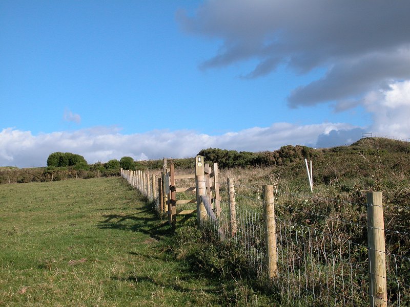
Now things become simpler again. On the northeast corner of
this little green you will see a large gate bearing the sign, “Mount
Edgcumbe
Country Park”. Go through the gate to find yourself at the south end of
a long
sward of grass, sloping up to your left.

Entrance to Mount Edgcumbe estate


Parkland north of Kingsand
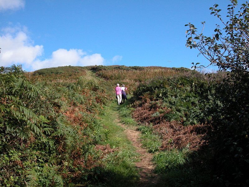
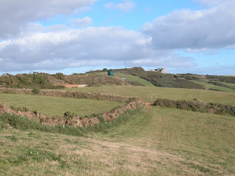
This area is marked as “Minadew Brakes” on the map. Although it’s part of the Mount Edgcumbe estate you won’t reach Mount Edgcumbe proper for a couple of miles yet. The grassy stretch is supplied with plenty of bench seats and rewards you with a view across Plymouth Sound to Staddon Heights and Bovisand Bay opposite. You’re also nearly end-on to Plymouth Bar here. You can’t see Plymouth itself but if you look along the coast to the northeast you will see the semicircular edifice of the old Picklecombe Fort about a mile ahead. The fort has been “let go” by the military and now functions as residential flats, but the coast path keeps well inland from it as you will shortly discover.


The approach to Picklecombe
At the far end of the open grassland area you enter a very
pleasant stretch, treading a wide and well maintained path running
through
patches of mature woodland interspersed with open areas. This section
continues
for a good mile and rewards you with excellent views across the Sound
plus some
delightful woodland dells. Picklecombe Fort looks ever nearer. There
are a
number of gradients so don’t expect this section to be effortless.
There are
still a few bench seats dotted here and there, and the occasional
superfluous
coast path marker.


The coast path north of Kingsand


Approaching Hooke Lake Point
Eventually you spot a building ahead and the path delivers
you onto a road; you’ve reached Hooke Lake Point and now, where you
really need
a coast path marker, there isn’t one to be seen. Go to your right. This
is the
public road to Picklecombe Fort but you don’t follow it very far; not
fifty
metres ahead a coast path marker is seen, directing you through a gate
to the
left. You find yourself on a path running steeply uphill through a
patch of
open heathland; at first it runs
parallel with the adjacent road but road and path soon diverge and the
heath
gives way to mature woodland.


Turn left here; heathland slope;
woodland path


The path through mature woodland near Picklecombe
This is a lovely stretch indeed, albeit rather dark and
therefore not easy to photograph well. The path is broad and even and
is
floored with leaf litter that resembles gravel, an excellent walking
surface
and probably the easiest rural section of the whole coast path.
Rhododdendrons
line the path, giving a bold splash of colour during May and June when
they’re
in flower. The path twists and turns a lot, and unless you study the
map it’s
not really apparent that the woodland path is skirting high above
Picklecombe
Fort in a broad arc. The dense woodland denies you a view of the sea.
Look out
for the stone folly containing a bench seat at a right-hand bend, the
halfway
point of this woodland section.


The coast path west of Picklecombe Fort


Rhododdendron groves west of Picklecombe
Once you’re past Picklecombe Fort and the rhododdendrons,
things change. The woodland becomes more open. Then the path hits a
bewildering
series of diversions. You’re just proud of the upper park area of Mount
Edgcumbe here and there is a veritable maze of woodland paths
zig-zaging up and
down terraces and visiting half-hidden stone follies. The coast path
used to
follow a simple broad path through the middle of all this but a
landslip in the
winter of 2003 has necessitated a rerouting onto the path maze. This
would be a
thoroughly enjoyable interlude but for one thing – the pitiful lack of
waymarks. It’s OK at first and you find yourself zigzagging left and
right up a
series of woodland terraces, but then you reach a point at which you
have to
infer the route from the ocasional waymarks placed for those going east
to
west. It’s annoying, it’s confusing and it’s frustrating. You should,
eventually, find yourself walking past the stone folly pictured below,
the
highest elevation of the diversion. Now you start zigzagging down
again, partly
on obviously newly made paths as illustrated.


Diversion routes through the woods
It’s when you reach the foot of the longest stretch of new
path that the worst confusion occurs. Another new route descends a
flight of
steps ahead of you and doglegs back to the south, while a mature, broad
path
crosses left to right. No waymarks at all. Which way to go? If I hadn’t
encountered some walkers coming the other way at that point I’d have
taken the
broad path to the left and made an error – it would have led me to
Mount
Edgcumbe house rather than along the coast path proper. The correct way
is down
the steps, then along the path for a hundred metres to the southwest to
a sharp
dogleg, then back along a lower path where at long last there’s a coast
path
marker, pointing you down a path to the right.


The coast path runs down to the shoreline
Now the nature of the walk changes again. For the first time
since Portwrinkle the coast path comes right down to the shoreline and
you find
yourself in open woodland with a grassy floor, and the path here is
quite
tentative. In fact, when I first walked this section in 1994 there was
no path
at all and walkers were left to pick their own way through the trees.
You come
out onto a little pebbly beach from where you get your first decent
closeup
view of Plymouth itself, and the Hoe and its obelisks and terraces is
clearly
visible. Save your film or your card memory, however, for there are
even better
views of the city not far ahead (not to mention Mount Edgcumbe park and
gardens). Just beyond the viewpoint the path is routed across a marshy
section
on wooden planking, after which it begins to run uphill into the wood
once
more. At a partly open section you reach a gate in a high fence; this
is a deer
fence and you’re entering Mount Edgcumbe park proper.


The shoreline and Plymouth Sound


Approaching Mount Edgcumbe upper park
A few hundred metres beyond the gate you come out into an
open space, and up to your left is a ruined stone tower, another folly.
The
path goes downhill into mature woodland again. Another couple of
hundred metres
further on you reach the first section of parkland proper. This is
where you
get the better views of Plymouth. The path curves around to the right
beside a
low stone wall, but to your left is a little circular portico and
beyond this
is a lovely little pond, fringed with trees and shrubs and surrounded
by lawns.
It’s worth a walk around. Head back to the coast path and go through a
further
stretch of wood. You emerge from this onto a vast swathe of parkland,
which
will undoubtedly be busy with day trippers. The path becomes a vehicle
track.


The Folly; woodland path; view of
Plymouth


First parkland of Mount Edgcumbe


The Pond


Mount Edgcumbe
Take the path around to the right. You’ve now reached
Wilderness Point, the headland at the narrowest part of the Tamar; it’s
just
four hundred metres from here across to Devil’s Point in Plymouth. A
restored
battery, complete with naval cannon, stands on the coast at this point
and to
our left is a large rectangular patch of grass, an old bowling green,
backed by
a huge yew hedge. An old blockhouse stands adjacent to the battery at
the
northern end of the hedge. The path now rounds a corner to the left and
you see
the ferry terminal at Cremyll a few hundred metres ahead, but first the
path
runs through Mount Edgcumbe’s formal gardens.


Bowling green and battery


Cremyll, and approaching the formal gardens
The path comes out in front of the Orangery, nowadays a
cafeteria. There’s a toilet block in the rear of the building at the
far end but
you will be drawn to the Italian Garden in front of the orangery with
its
fountain and its marble balcony at the far end. Take either path away
from the
balcony and you will find yourself in a little maze of formal gardens.
They are
not extensive but they pack a lot in and will take a good hour to
explore; each
section within the gardens is themed and you will find the English
Garden, the
French Garden, the New Zealand Garden, the Rose Garden and the Fern
Garden
among others. Look out for the Geyser, which spouts a fifteen foot
fountain for
about ten seconds every minute or so. There are two summer houses
within the
gardens and plenty of bench seats.


The gardens at Mount Edgcumbe


A portfolio of the formal gardens at Mount Edgcumbe


The formal gardens and the geyser


More photos of the formal gardens at Mount Edgcumbe
Finally you emerge into parkland and see Mount Edgcumbe
House itself, at the far end of a broad grass slope. The house can
apparently
be visited though I’ve not actually done so myself. The house dates
from 1540
but what you see is a restoration following a fire in the 1940’s. The
grounds
as a whole became a country park in 1970 and there has been free public
access
since that time.


Mount Edgcumbe park and house
Once you can tear yourself away from the park go through the
gates at the north end to reach the tiny hamlet of Cremyll, the last
village in
Cornwall. It consists of the harbour buildings, a pub called the
Edgcumbe Arms
and a couple of cottages. The passenger ferry to Plymouth leaves from
here –
there is nominally a half hourly service until mid afternoon after
which it
reverts to hourly, and in summer it continues to operate into mid
evening. The
hourly 81B bus from Plymouth via Whitsand Bay, Antony and Torpoint also
runs
from here but it’s a ninety minute journey by bus as opposed to a ten
minute
crossing by ferry, so unless you’re headed somewhere other than
Plymouth itself
the bus is an option not worth considering.


Mt Edgcumbe gatehouse; Plymouth Sound from
Cremyll; The Edgcumbe Arms
As you cross the Tamar you leave Cornwall and enter Devon, and the City of Plymouth.
The city of Plymouth is, by a very long way, the largest place on the route of the End-to-End Walk. (Technically the End-to-End also wanders just inside the municipal boundaries of the city of Edinburgh, but as it doesn’t actually touch the built-up area the Edinburgh incursion doesn’t count).
The city lays immediately to the north of Plymouth Sound, a
bay roughly three miles square that forms a huge natural harbour. The
Sound
contains a number of smaller bays and inlets, not least the mouth of
the river
Tamar which enters the Sound on its northwestern corner and which
itself is a
vast complex of estuaries, inlets and creeks. The river Plym, from
which
Plymouth takes its name, finds its way into the Sound at its
northeastern
corner. The Sound is bounded to the south by Plymouth Bar, an
artificial
breakwater a mile long that serves to protect the Sound from the swell
and the
currents of the open ocean.


Armada Way
Plymouth is a fascinating place with a rich
maritime
history. The city was originally three separate coastal villages –
Sutton,
laying on the west bank of the Plym, Devonport, situated on the east
bank of
the Tamar, and Stonehouse, midway between them on the minor inlet of
Stonehouse
Pool. By the mid 1500’s they had amalgamated into one town, Plymouth,
which had
become Britain’s premier naval centre (and for a time the largest
built-up area in Britain). The navy is still based at Devonport and
in fact the dockyard here is now the largest naval base in western
Europe.
Although warships are no longer built here Devonport is home to a large
fleet and
it berths, repairs, refits, services and provisions the greater part of
the
British Navy. Some of the older parts of the dockyard south of the
Torpoint
ferry are being returned to Plymouth city council for redevelopment.


Armada Way and the sundial, Plymouth city centre
In the days of the great ocean liners the dock at Millbay
(between Stonehouse and Plymouh Hoe) served as a passenger liner berth,
and
nowadays it functions as the terminus for vehicle ferries to Spain and
France.
The huge concrete building beside the dock, arguably the ugliest
building in
Devon, is a former grain silo and is apparently retained to proect the
dock
from the prevailing winds. The imposing Duke of Cornwall Hotel still
stands
nearby, a landmark on the coast path. Sutton harbour, east of the Hoe
and the
original heart of Plymouth, is now a huge marina dedicated to leisure
craft,
small cruise vessels and passenger ferries, while a little further east
the
Plym estuary (otherwise known as the Cattewater) is home to a number of
commercial wharves. The new National Maritime Museum stands on the east
side of
the harbour and has become a major tourist attraction. There is yet
another
marina at Stonehouse, which is also the terminal for the passenger
ferry to and
from Cremyll that joins two legs of the coast path.


The foot of Armada Way between the city centre and
the Hoe
The aforementioned Plymouth Hoe is a small limestone ridge
that stands right on the north edge of the sound, seperating the
seafront from
Plymouh city centre. It has always been a public recreation ground.
Nowadays
it’s laid out as a park with a huge hard stand (the Promenade) that
occasionally houses fairs and similar events. It was on Plymouth Hoe
that Sir
Francis Drake was reputedly playing bowls when news reached him of the
imminent
arrival of the Spanish Armada. Drake is just one of a number of
historical
naval figures associated with Plymouth, for a great many voyages of
discovery
and exploration set out from here. Sir Walter Raleigh, Drake’s
contemporary,
was based here. Captain Cook’s three great voyages of exploration left
from
Plymouth. The Pilgrm Fathers left Sutton Harbour on the Mayflower in
1620 to
set up a colony in what is now the USA, and it was the first of a
number of
great voyages of colonisation. Captain Bligh, of Mutiny on the Bounty
fame, was
a Plymouth man. Darwin sailed from Plymouth on the voyage that led him
to
formulate his theory of evolution, Robert Falcon Scott sailed from here
to
become the first Briton to reach the south pole, and Sir Francis
Chichester
embarked from and returned to the small harbour on West Hoe to make the
word’s
first solo circumnavigation in 1966. Just across the Plym from Sutton
Harbour
is Mount Batten, a former seaplane base from where the first
transatlantic
flight was made in 1919 and at which T.E. Lawrence (a.k.a. Lawrence of
Arabia)
served in the Navy.


The ferry landing at Admiral's Hard; the
streets of Stonehouse


Millbay Docks and the Duke of Cornwall Hotel
The Coast Path reaches Plymouth at Admiral’s Hard on the
east side of Stonehouse Pool, then passes an industrial area and rounds
Millbay
Dock to reach the Hoe. Strictly it runs around the coast road from here
but
most visitors will want to go up to the Hoe itself, so turn left from
Hoe Road
into Cliff Road to reach the Promenade. Surrounding the Promenade is a
huge
grassy sward, part of which is laid out as gardens. The Hoe is home to
a number
of obelisks, memorials and other commemorative developments, not least
Smeaton’s Tower, the lightouse that used to stand on Eddystone Rocks
some 18
miles out to sea. The adjacent Belvedere is a series of terraces
leading down
from the Hoe to the sea front, and next to that is Plymouth Dome, a
recent
visitor attraction that tells the story of Plymouth and is well worth a
visit.
It also contains a shop and a café. Tinside Lido and the
adjacent collonade and
terraces lay seaward of the Dome and the coast road. On the eastern end
of the
Hoe is the Citadel, an imposing military fort built by Charles II in
the
aftermath of the civil war. There are several other forts in and around
Plymouth, commissioned and built by various monarchs and governments
through
the ages – not one of them has ever fired a gun in anger and those
built in the
Victoian era by Palmerston as a defence against the French are now
collectively
known as Palmerston’s Follies. Some, like the Citadel, are still home
to
various parts of the Navy, the Army and the Marines, while others have
been
sold off for conversion into residential flats. West of the Hoe is a
grid of
streets of smart Regency terraces, home to Plymouth’s largest cluster
of
tourist accommodation.


Arriving on Plymouth Hoe; view west to Mt
Edgcumbe; the Promenade; view east to Staddon Heights


The Promenade


The Promenade, and the view across West Hoe to
Mount Edgcumbe


Drake's Island and Mount Edgcumbe seen across the
lido; Smeaton's Tower; Plymouth Dome


The Hoe from the east; the Citadel


A gun battery near the Citadel; approaching
Sutton Harbour; the National Maritime Museum
The coast path doesn’t touch Plymouth city centre but there
can’t be a single coast path walker who doesn’t make use of its many
facilities. The city centre lays immediately to the north of the Hoe.
It
suffered badly during the second world war and was almost completely
obliterated by the Luftwaffe. The modern city centre was built in the
1950’s by
Abercrombie to replace the wartime ruins, and features a grid of wide
and
largely pedestrianised streets fronted by buildings in white Portland
stone.
Its central boulevard, Armada Way, runs due north from the Hoe to the
railway
station and is some three quarters of a mile long.


The original heart of Plymouth around Sutton harbour
survived the bombing. Known nowadays as the Barbican, it is a place of
great
character crammed with narrow lanes and buildings dating back to
medieval
times. A good proportion of the city’s nighthlife is found here. The
old fish
wharf on the quayside has been reborn as a glassworks and gift shop,
the city’s
tourist information office is found here, and it’s here that the Coast
Path
ends at the Mayflower Steps, the mooring from which the Mayflower left
Britain
for the New World.


Scenes around the Barbican and Sutton Harbour
A number of plaques around the harbour walls tell of
not
only the Mayflower but also many other voyages that left from Sutton
harbour,
and it says a great deal about Plymouth that these plaques have never
been
vandalised or defaced by graffiti. For those setting out to walk
onwards along
the South Devon coast path (perhaps to turn off at Bovisand for the
Devon Coast
to Coast walk), the adjacent yellow boats of Mount Batten Ferries run a
half-hourly service across to Turnchapel on the opposite side of the
Plym.


|
£4.00
inclusive
of postage / packing. |
| Looe to Portwrinkle | Back to South Cornwall Coast Path index | Plymouth to Yealmpton |
This page last updated 29th January 2006
![]()