| Polperro to Looe | Back to South Cornwall Coast Path index | Portwrinkle to Plymouth |
| Polperro to Looe | Back to South Cornwall Coast Path index | Portwrinkle to Plymouth |
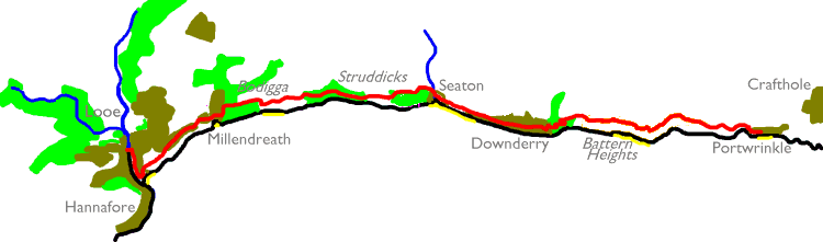
There are several small villages between
Looe
and Plymouth and all of them are on public transport routes so it's
really
a matter of choice where you make your overnight break. I plumped for
Portwrinkle,
which is visited only by a couple of buses per day though Crafthole,
not
much over ten minutes' walk inland, has a far more regular service.
It's
barely more than seven and a half miles from Looe to Portwrinkle but it
does contrive to feel much longer, for yet again there is a good deal
of
up and down work to tackle and the continual reascents are tiring.
There
is rather more variety to the route than there was yesterday between
Polperro
and Looe; a good proportion of the route lies in or near built up areas
such as Seaton, Downderry, Millendreath and Looe's extensive eastern
limb.
The rural parts provide a mix of woodland, scrubby slope and open
pasture
though there is no real cliff or rock scenery. Parts of the route reach
a surprisingly high elevation, particularly Battern Heights beyond
Downderry
(at 462 ft the highest point of the South Cornwall Coast path). A
dramatic
moment occurs on these heights when, quite suddenly, the first view of
Plymouth opens up before you with the dark heights of Dartmoor beyond.
|
|
|
| Length: | 7.8 miles / 12.6 km |
| Total ascent: | 1969 ft / 600 m |
| Total descent: | 1976 ft / 602 m |
| Estimated time: | 3 hrs 15 mins |
Map: OS 1:25000 Explorers 107 (St Austell & Liskeard) and 108 (Lower Tamar Valley & Plymouth)


Looe River


Looe: bridge, river, Station Road
We begin today's journey at Looe Bridge, which links West Looe to East Looe across the Looe river. You may already have taken a good look around Looe at the end of yesterday's walk, in which case you will already be aware that East Looe is the town centre. I've already said a few words about Looe on the previous page and I won't repeat too much here. East Looe is cramped, and crowded into narrow lanes just like Polperro. It targets the tourist unashamedly and has gone decidedly downmarket - so many of its shops sell tourist tat, and in its many cafes you will be hard pushed to find anything on the menu that doesn't include chips.
![]() The Looe
directory
The Looe
directory


East Looe
There is charm in East Looe, though, plus several hidden delights, if you choose to seek them out. Just as in Polperro it can be rewarding to wander at random and poke your nose into shop doorways. At one point you will discover a block of four impossibly narrow lanes in a grid layout, and inevitably you will find yourself at the harbourside moments later.


Narrow lanes of East Looe


Looe Harbour
The harbour is a busy place, and unsurprisingly is a departure point for a variety of boat trips. It seems that Looe is the centre of Britain's shark fishing activities, such as they are, and the boat trips include a number of sightseeing and wildlife-spotting opportunities.


Looe harbour and beach
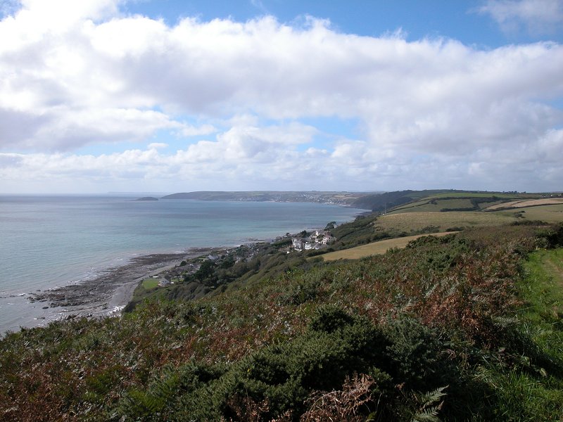
Just around to the left from the harbour is the beach. It's not really a pretty sight, just a meagre stretch of sand hemmed in by a complex of concrete sea walls, but the view to the east is quite inviting. Rame Head, only six miles short of Plymouth, looks quite close now.

Coast path up from beach
The Coast Path leaves the beach by a series of flights of concrete steps, climbing the slopes in zig-zag fashion. At the top there is a rewarding view over the town and across to West Looe and Hannafore.


From the "landing" at the top of the steps a path follows a terrace to the east, and this is our route. The path runs for a good half mile, through partial tree cover, giving good coastal views throughout. Occasionally, side paths disappear off to the left and there will be occasional views of houses.


The coast path running below East Looe


Coast path approaching Plaidy Lane
Eventually the occasional glimpses of houses become more numerous, the path widens and improves, and suddenly you emerge onto a residential road. This is Plaidy Lane, East Looe's most desirable residential limb and a paradise of dream houses and cottages overlooking the sea.


Plaidy Lane
Plaidy Lane runs high above the coastline. The lane is a dead end; all at once the lane turns to the left away from the coast. Keep a look out for the steep, narrow path that heads up to the right between residential properties. It's a short pedestrian route up behind the steep inlet of Millendreath Beach.

Path to Millendreath


Millendreath, and descent to the beach
Millendreath is an isolated little community, largely a holiday village, that clusters around a beach backed by steep cliffs and runs for about 500m back along the valley inland. Having climbed up from Plaidy Lane you first encounter another smart residential road, and then another little path beside a house that disgorges you onto a viewpoint above Millendreath near the top of the west cliff. A steepish path winds purposefully down to the beach, passing a bar / restaurant that is presumably the focal point of the holiday village.

Descent to beach


Millendreath holiday village and beach

Millendreath beach and sea wall
The coast path's encounter with Millendreath is short and sweet. Walk along the roadway behind the beach and sea wall and follow the lane steeply up to the northeast, among yet more highly desirable houses and cottages with lush gardens. Near the top end of the village the coast path resumes to the right.


Retrospective view of Millendreath

Coast path to Bodigga cliff


The coast path and lane above Bodigga cliffs
Immediately beyond Millendreath is a short stretch of path that is well hemmed in by trees. It emerges onto a motor road (second picture above), which you follow for a couple of hundred metres towards the locality of Bodigga. Look out for a coast path sign directing you down a path to the right.


Bodigga Cliffs access path and viewpoint
The access path comes out onto a wide swathe of open grassland, set out with a handful of picnic tables, a good place for a morning refreshment break. You're at Bodigga Cliffs, and the viewpoint gives a grand retrospective vista back across Millendreath, Looe and Hannafore towards Hendersick Point. Head towards the southeast corner of the grassy pasture, where you will find the continuation of the coast path.


Coast path east of Bodigga Cliff
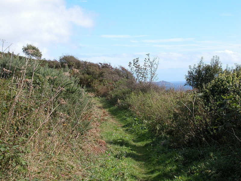
The nature of the scenery changes completely at this point for you return to the kind of terrain that characterized the Fowey - Polperro stretch of two days ago. The path traverses a mile of sloping scrub and woodland, and does so by means of a good many twists and turns and ascents and descents.


Coast path below the monkey sanctuary
This is a lonely and tiring stretch. There is a long woodland section, for which the weather has to be just right - under dull skies it's gloomy, on a hot day it's stifling, but under the dappled sun of a spring or autumn day it's one of the prettiest sections of the whole coast path. You will see a number of "danger, keep out" notices to your left - you're passing below the Looe Monkey Sanctuary, a visitor attraction well worth a look if you have time. It opens from 11 to 4.30, Sundays to Thursdays, between Easter and September. You should allow two hours for a visit. There is no access from the coast path - instead, walk along the lane from Millendreath or from Seaton.


Coast path, Struddicks
A good mile after leaving the Bodigga Cliff viewpoint the nature of the walk changes again, as you emerge from the woods onto an area of relatively open pasture. You're on National Trust territory here, and this locality is known as Struddicks. You're on an outward curve of the coastline so views ahead are restricted, but the retrospective views of Looe and Hannafore continue to delight.


Struddicks, and Seaton woods
The coast path suddenly turns leftwards and plunges into woodland once more. The wood is barely noticeable on the map but is actually quite dense and serves to shut out a good deal of light. A remarkably steep flight of steps at the far end of the wood drops you - almost literally - onto the coast road into Seaton.

Steps down to coast road


Approaching Seaton
Seaton is a small but strategic locality roughly halfway between Looe and Portwrinkle. A small village, it clusters around a sandy beach and a large village green, and has the usual facilities such as a beach cafe. There is about 400m of road walk from the steps from the wood into Seaton, of which the latter 200m is residential. Seaton makes an obvious lunch stop and is a pleasant place to linger awhile.


Seaton village


Sea front and village green at Seaton


Downderry is effectively a residential
extension
of Seaton to the east, but it is actually rather larger. The official
guidebook
suggests that the sea wall east of Seaton is the preferred route,
though
it is a rather unscenic option and the beach itself might be preferred.
A local authority notice tells you that you should use the road through
Downderry rather than the sea wall, as the latter is in bad repair. In
either event, the distance either through or below Downderry is about a
mile.


Walking through Downderry
The walk through Downderry is most
pleasant - the place has quite a refined air and is characterised by
large and rather smart houses, many of them gleaming white.
If you choose the sea wall / beach option,
walking is relatively swift if rather uninteresting. Ignoring various
ramshackle
constructions of steps and ladders leading off from the beach, make
your
way to an obvious slipway and take the road northwards into the
village.
The sea wall and village routes converge towards the east end of
Downderry,
about 1.8km from Seaton beach.


Scenes in Downderry


There's probably another 200m of Downderry
to walk through. Look
out
for the stream and its smart environs right near the eastern edge of
the
village. Once you're past the last houses the road runs for a further
200m
through open country before veering left around a sharp bend. Just over
half way round this bend, right beside a house, is a pathway up to
Battern
Cliffs.


The eastern outskirts of Downderry


Coast path marker and path to Battern Cliffs


Path to Battern Cliffs
The pathway up from Downderry to Battern Cliffs is well constructed, and incorporates zigzags and flights of steps. It gains height quickly and it needs to, for the cliffs mark the highest elevation of the South Cornwall Coast Path, at 462ft.


Battern Cliffs
There's just over two miles to walk
between
here and Portwrinkle but they are long and tiring miles, and once again
you are on the familiar territory of clifftop walks and scrubby slopes.
It's tiring work. First, however, you have Battern Heights to climb.
Having
got to the initial stage of the clifftop the land continues to rise,
but
more gradually. All the views are behind, and once again they encompass
all the country walked today and the latter half of yesterday, back to
Hendersick Point.


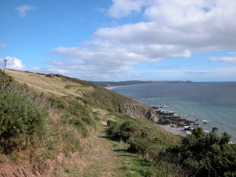
Battern Cliffs
Battern Cliffs consist of a steepish face
topped by a shallower slope cloaked by scrub, and you really only see
this
shallow slope. Quite suddenly you reach the highest point of the path
and
the view sweeps down across the Cawsand peninsula towards the Tamar
estuary,
with Plymouth crowding the far bank. It's a dramatic moment and it
brings
home to you quite forcefully that your fortnight's journey along
Cornwall's
dramatic coast is nearly ended.


The summit of Battern Cliffs and the first view of
Plymouth


Battern Cliffs
A few moments later you approach a motor
road,
the B3247 Seaton - Crafthole - Cawsand road. Up to very recently the
bulk
of the day's remaining miles were routed along this road for two
reasons
- there was no designated right of way for much of the distance from
here
to Portwrinkle, and part of the coast had suffered a landslip that had
obliterated a section of the unofficial path that was gradually
appearing.
Now, fortunately, these problems have been addressed and a new right of
way has been established for this last mile and a half. It occasionally
hugs
the top of the slope, at other times dropping down among the scrub to
resume
that all too familiar rollercoaster of descent and reascent. You've
probably
started to tire now, and a series of stiles will bring home that
tiredness.
Fortunately Portwrinkle gets noticeably nearer with every step.


Battern Cliffs to Portwrinkle


The new path to Portwrinkle


| Polperro to Looe | Back to South Cornwall Coast Path index | Portwrinkle to Plymouth |
This page last updated 28th January 2006
![]()