| Ivybridge to Dartmeet | Back to Devon Coast-to-Coast index | Chagford to Morchard Road |
| Ivybridge to Dartmeet | Back to Devon Coast-to-Coast index | Chagford to Morchard Road |
I discovered the route north of Dartmeet entirely by accident, whilst walking with a group of friends in the summer of '92. Some of the photos from that walk appear below and so, unusually in these galleries, you will see walking companions now and again.. It was a direct result of that day out that I decided (1) I wanted to include Dartmoor in my Walk, even at the expense of introducing a giant dog-leg across Devon, and (2) I was going to ignore the official line of the Two Moors Way and include that delightful, unmapped walk north of Dartmeet in the route.
The key to this walk is the summer bus
service
that runs between Newton Abbot and Tavistock and calls at Dartmeet,
daily
between mid July and late August, Sundays only through the rest of the
summer. There's a similar bus service that calls at Postbridge, a tiny
village half way into the walk, which would allow you to break up the
walk
into two half days should you wish. Chagford, at the end of the walk,
has
a regular though rather sparse bus service, and on some occasions it's
necessary to walk out to the crossroads at Easton.
Map: OS 1:25000
Outdoor Leisure 28 (Dartmoor)

Badgers Holt


The East Dart at Dartmeet
![]() Bus
service
172,
Totnes - Newton Abbott - Dartmeet - Tavistock, 2002 timetable for summer
Sundays and bank holidays, and weekdays mid
July
to mid August
Bus
service
172,
Totnes - Newton Abbott - Dartmeet - Tavistock, 2002 timetable for summer
Sundays and bank holidays, and weekdays mid
July
to mid August
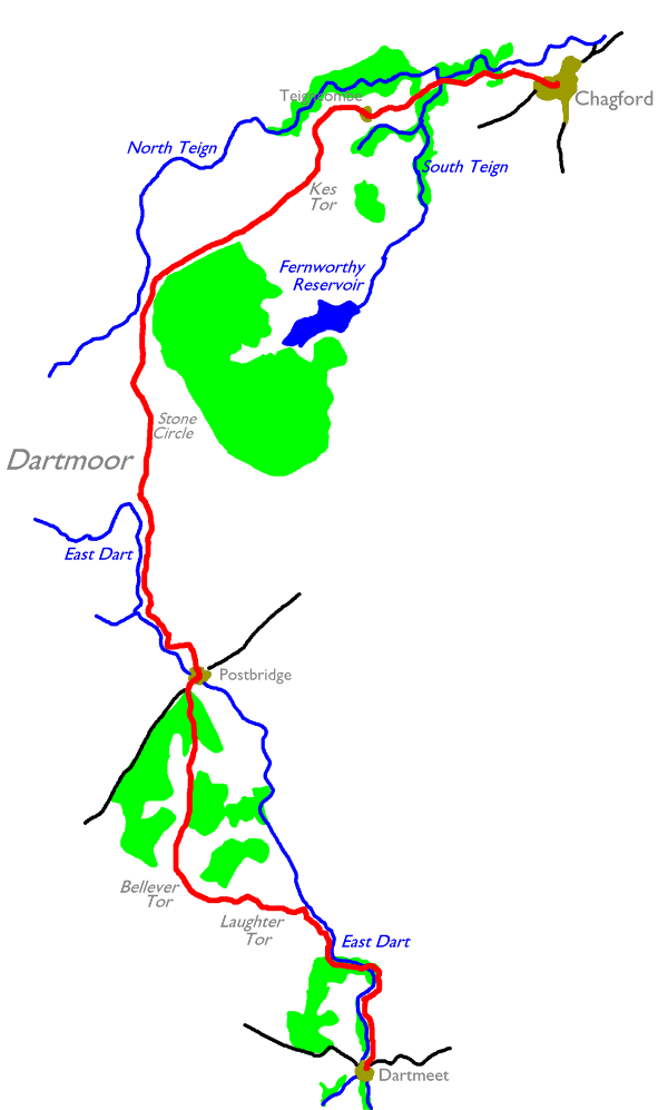
Dartmeet is a little bit of heaven on Earth. Situated at the confluence of the East and West Dart rivers, it occupies a rocky but lushly wooded little dell nestling among the surrounding moorland heights. A tiny motor road meanders through the locality, crossing both branches of the Dart on highly-arched stone bridges. The place does target the tourist - there's a large car park and associated "retail opportunities" immediately east and north of the main road bridge, but the principal retail opportunity is Badgers Holt and just happens to be one of the best tea shops in Britain.

The path north of Dartmeet
Our route north, not even marked on the Ordnance Survey's 1:25,000 Outdoor Leisure map of Dartmoor, squeezes initially through a gate to the left of Badgers Holt. You pass between the buildings and the river to enter a green playground, a mix of heath (with its characteristic mix of gorses and brackens) and wooded river meadows with the East Dart close by to your left.


The East Dart north of Dartmeet
The path along the east bank of the East Dart is lovely - there's no other word for it. The mixture of meadow and heathland environment is curious but makes for an almost perfect walking environment. It's probably far too soon to stop for a refreshment break, particularly if you've just experienced a Badgers Holt cream tea, but you're here to enjoy yourself after all. What else is the great outdoors for?


The heathland / river meadow scenery beside the East Dart
The general heath / meadow scheme continues for about a mile, after which the river and accompanying path swing around to the left and the vegetation starts to crowd in. It becomes rather more of a woodland walk from here on, though the East Dart, babbling and jumping over rocks to your left, is a major plus point.


Scenes adjacent to the East Dart
Not long after the curve to the left - though rather longer than the map would suggest - you come to a prominent set of stepping stones across the East Dart. Your route lies across these stones, a crossing that should be benign most of the time but might be rather chancy should the river be in spate.


The stepping stones; the Stumbles walking group tackling the stones in '92
As you cross the East dart via the stones you leave Teignbridge district behind and enter the district of West Devon

On the west bank of the East Dart is a dark little wood known as Newtake Plantation. A path - still not marked on the OS map - follows the riverbank to the west, emerging into open country around 800m further on.


Laughter Hole
You now find yourself in the open valley of Laughter Hole, an area of open heath that the East Dart has carved itself between the heights of Riddon Ridge (to the right) and Laughter Tor (to the left). There's still no path of the map, but a very obvious route runs, about halfway up the slope on the west bank, northwestwards towards Laughter Hole House.


The route in the valley of Laughter Hole


Laughter Hole; the "stumbles" group stop for lunch; the route to Laughter Tor
The route approaches the southeastern tip of a fairly extensive stretch of conifer plantation; nestling within the outer confines of this plantation are Laughter Hole House and Laughter Hole Farm, one or both of which should be visible not far ahead. There doesn't seem to be any road access to either habitation. You have the option here of an alternative route through the woods via Bellever; there may or may not also be a riverbank path that you could follow to Postbridge. My recommended route, however, now tracks just north of west to take in the outcrops of Laughter Tor and Bellever Tor.


Virgin moorland near Laughter Tor; the summit outcrops; looking west to Bellever Tor
The ascent of the 420m summit of Laughter Tor is slightly adventurous in that you need to cross a few hundred yards of pathless moorland to access it. You already tackled pathless country yesterday so you're a hardened veteran now, and in any case it will be good practice for the Pennine Way later in the walk. The granite tors on the summit feature the usual wind sculptured bedding planes and vertical fractures, and rock climbers and scramblers will find a few minutes' worth of healthy exercise here.

Graham, Trish, Barbara and Alan on the summit of Laughter Tor
Track north of west off the summit, passing close to another corner of the conifer plantation, to a gate in a stone wall that gives access to Bellever Tor.


A prominent path northwards from the gate skirts the summit of Bellever Tor to the east; it's a simple matter to leave the path to tackle the short slope to the 440m summit of the tor, a noted viewpoint. The view across the Dart valley to the east and south is especially good - you should be able to see back to yesterday's high point of Ryders Hill - while to the north lies Bellever plantation with the village of Postbridge beyond. Way out to the northwest is the highest and wildest part of Dartmoor, home to the army's Okehampton artillery range and Yes Tor, at 619m elevation the highest summit in south west England. The BBC's radio mast at North Hessary Tor lies 7 km almost due west.


Bellever Tor's trig pillar; the Stumbles group take in the view; Graham on the summit


Dartmoor ponies on Bellever, and the route northwards into Bellever plantation
Another welcome feature of this area of Dartmoor is the famous Dartmoor ponies, which graze semi-wild over this vast area of open moorland. They seem to like Bellever in particular. You are advised not to feed them, but they seem pretty used to people and are very photogenic.
The route off Bellever Tor lies just east of north - the path into Bellever plantation is prominent and very obvious.


Bellever plantation; the approach to Postbridge
There's about 2.5 km of straightforward walking on forest track now, between Bellever and Postbridge. The path first skirts the edge of the forest then doglegs right and left to follow a prominent ride through the middle. On the approach to Postbridge you merge with an unclassified motor road that links Postbridge to Bellever village.

Postbridge
Postbridge lies on the lonely B3212 road between Yelverton and Moretonhampstead, one of only two roads that cross Dartmoor. The village - little more than a scattering of cottages and farms, really - huddles around the handsome stone bridge that crosses the East Dart.


There's barely more here than there was at Dartmeet, but the tourists have discovered it just as surely. There are some delightful little water meadows immediately downstream of the road bridge but the chances are that, if you were thinking of parking yourself here for a lunch stop, you will be obliged to share it with dozens or even hundreds of day trippers. It is, undoubtedly, a lovely spot.
![]() Service
82,
Exeter - Postbridge - Plymouth, 2002 timetables for Mon
- Sat and Sundays / bank holidays
Service
82,
Exeter - Postbridge - Plymouth, 2002 timetables for Mon
- Sat and Sundays / bank holidays
It's time to consider alternative routes here if you wish. Basically there are three options, and they involve going around the left, or the right, or through the centre, of the Fernworthy forest plantation some three miles to the north. The route I followed runs out to the left (or west) of the forest but any of the three options are both viable and rewarding. The centre option could involve heading for Merripit farm and then up to Stannon tor, or via Merripit hill and Assycombe hill, to enter the forest by any of a number of tracks and going one or the other way around Fernworthy reservoir. The eastern option involves Merripit hill again, then via Water Hill or Assycombe hill to pick up the Two Moors Way across Chagford common.
I shall describe the western option, which I followed in '96, and which passes the farm of Hartyland to follow the upper East Dart valley to the north


The pastureside path to Hartyland; waymark beside the East Dart
There are two options for the route out of Postbridge; a glance at the map will show that there are two public rights of way, one each side of the river bridge. I chose the path on the east bank, which diverges from the river somewhat and runs through a pasture or two to approach Hartyland farm. One field enclosure short of the farm the right of way turns left to head for the riverbank, then turns right to pass the farm hard by the riverbank and enter open country once again.


Hartyland to the river; riverside scene and re-entry to open country
There's a nice little patch of turf just by the side of the farm, a hundred yards short of the gate into open country; this is where I chose to have lunch on the walk in '96.


The path by the upper East Dart; open moorland west of White Ridge
There's some 2 km of path rising up to high moorland alongside the dwindling stream that is the upper East Dart, before the river curves round to the left and heads off into the wilds between Black Hill and Hangingstone Hill, on the fringes of the army artillery range. Our route continues almost due north and, in direct contrast to the opening couple of miles out of Dartmeet this morning, is well marked on the map but very sketchy indeed on the ground. The line is not in doubt, as you need only to head northwards into a shallow valley towards the skyline, with White Ridge rising to your right. The way is a little sloppy and this is probably the wettest ground you will find on Dartmoor, but about a mile north of the point where you left the Dart you reach a little col at about 480m elevation; very close by is the Grey Wethers stone circle.

Grey Wethers
Stonehenge it isn't, but the sense of awe generated by standing next to a stone circle in the midst of an expanse of empty moorland is no less. I can find no information about the stone circle save for the legend on the map, which includes the telltale word "restored". This presumably means that the stones have at least been re-erected; whether they are actually the original stones or whether some or all are replacements is unknown.

Long Ridge
From the col the route becomes very obvious, as the line begins to drop into a shallow valley heading for the north Teign not far ahead; track half right now, to converge with the left hand edge of the forest plantation that you can see to your right. This stretch is known as Long Ridge and there is a fairly obvious path, which the map shows entering the forest not far ahead. You could of course take this option but, having come out to this northwest corner of the forest, it's far more straightforward to stay out on the open moor.

Kes Tor Rock
Another kilometre further, down a slight dip and up another rise, brings you to the 437m Kes Tor Rock, a rather daunting outcrop that has been in view for nearly three quarters of an hour and has been steadily growing in size. It's not the highest summit in this northeastern sector of the moor but, standing directly above the north Teign valley as it does, it is one of the most prominent. You'll still be able to see it from Two Barrows on the southern edge of Exmoor, which of course will be visible from here on a clear day.
The view is gorgeous, of course; you're looking along the north Teign valley towards Chagford and Castle Drogo, and beyond and to either side is the vast sweep of mid Devon. On clear days you may well be able to see much of the east Devon coastal strip between Torquay and Exeter, with perhaps Exmouth and Budleigh Salterton beyond.
Your route beyond Kes Tor continues northwest across a tongue of high ground and an area of rocky heathland, beyond which an obvious path drops smartly off the edge of the moor to the village of Teigncombe directly below.


Scenes near Teigncombe
The 3 km walk along the Teign valley is the coda to Dartmoor's symphony, a delightful pastoral aftermath to the two days of high, empty moors and open skies. You pick up the route of the two Moors Way once again at Teigncombe (just another tiny scattering of cottages) and then walk eastwards along a narrow, winding, tree lined back lane. The North Teign itself is hidden within its own little ravine among the woods to the north; there are a number of paths through the wood should you chose to make the diversion.

Holystreet manor
The lane winds its way eastwards, with the Teign still just out of sight in the woods to your left. A mile short of Chagford you pass the fancy stonework of Holystreet Manor. At a crossroads some 400m beyond the Two Moors Way doglegs to the left to follow a riverside path on the Teign's north bank; in doing this the TMW bypasses Chagford. We need to keep straight on at the crossroads in order to walk the final 900m into Chagford itself.


Street scenes in Chagford
Chagford is a very pleasant little place, village sized but afforded the status of a town by virtue of having a compact little shopping centre and being the biggest settlement for miles. It has a good deal of charm but suffers a little by being off the main road; the A382 Newton Abbot - Okehampton road lies a mile and a half to the northeast and you may have to walk out to the crossroads at Easton for a bus. Alternatively there are coffee shops, pubs and inns at Chagford and it would make a very convivial place for an overnight halt.
![]() Chagford's parish
website
Chagford's parish
website
![]() Bus
services to/from Chagford (Mon - Sat) and Sundays/Bank
holidays to/from Easton Cross
Bus
services to/from Chagford (Mon - Sat) and Sundays/Bank
holidays to/from Easton Cross
| Ivybridge to Dartmeet | Back to Devon Coast-to-Coast index | Chagford to Morchard Road |
This page last updated 16th January 2005
