|
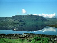
The sheer beauty of Loch Torridon,
seen from our B&B in Inveralligin at breakfast time.
|

|
Beinn Sheildaig across the
loch
|
|
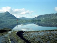
A truly tranquil scene, the surface
of the loch is so still that it's almost acting as a mirror.
|

|
Looking across to Shieldaig
once more.
|

|
The foreshore of Loch Torridon.
|
|
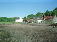
Part of the tiny village of
Inveralligin.
|

|
Looking across the loch from the
driveway of our B&B.
|

|
After breakfast we drove the short
distance to the east, to leave the car at a car park at the foot of the
Coire Mhic Nobuil, just above Torridon house. Just upstream from the
bridge is this splendid little waterfall.
|
|
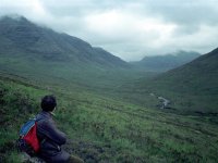
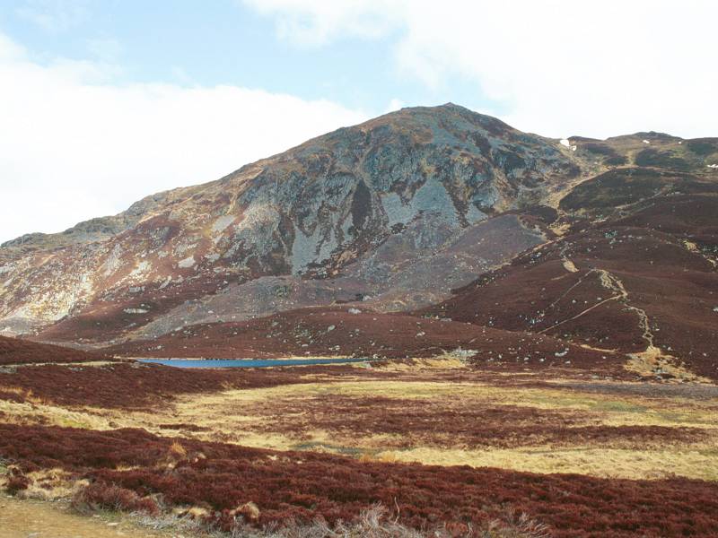
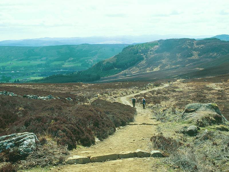
It's probably a couple of hours
later. We've walked through a strip of forest to emerge into the upper
glen, a wild place sandwiched between Beinn Alligin to the northwest
and Liathach to the southeast. We've then left the main path through
the glen for another path leading into the Coir nan Laogh, the first of
the two great corries in Alligin's east face. The terrain is very
marshy at first but improves as the path gains height.
|
|
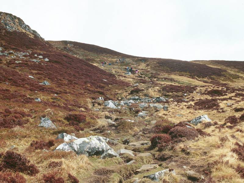
We're quite a way up into the
corrie. As you can see, the weather didn't maintain its early promise
but the cloud cover is still light and we don't think there's any
threat of rain.
|

|
The corrie curves gracefully - but
steeply - around to the right. I really felt this ascent, in fact it
remains the most punishing I've ever undertaken. I didn't know it at
the time but I was going down with a heavy cold, which probably
explains why I felt the effort so much.
|

|
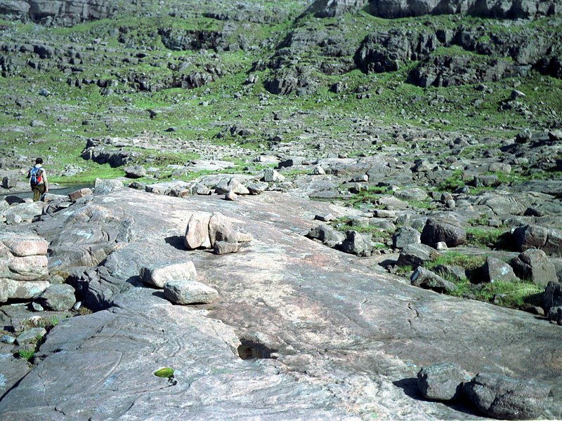
We're high into Coire nan Laogh
here and seeing the celebrated bedding planes of Torridonian sandstone
close up. Unsurprisingly we were not alone on the walk. Due to my
restricted pace most other walkers overtook us easily. I actually lost
sight of Graham for ten minutes or so but I knew he wasn't far above me.
|

|
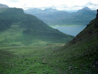
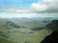
We're looking out across the mouth
of the corrie here and seeing Upper Loch Torridon laid out before us,
with Beinn Damh (to the right) and Beinn na h-Eaglaise (to the left)
oppisite.
|

|
Some low cloud scuds across as we
approach the saddle at the top of the corrie.
|

|
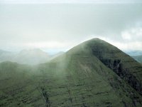
The top of the corrie and our first
view beyond. That's Baosbheinn over there, and to its left is the wild,
lonely country of Sheildaig Forest and a hint of the coastal village of
Gairloch.
|

|
It's now just a short climb up to
the right to gain Tom na Gruagaich, Beinn Alligin's south top. Six
years after our ascent Gruagaich was promoted to Munro status.
|

|
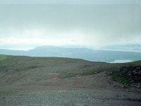
A look back at the way we came up.
The peaks on the south side of Loch Torridon are still just visible but
that cloud is scudding in from the west.
|

|
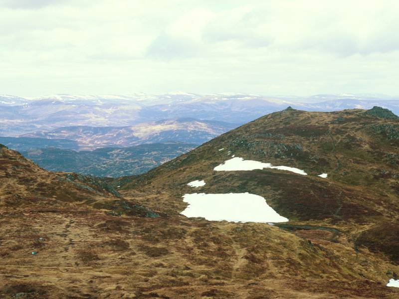
We're at the top of Tom na
Gruagaich, looking due north. The main ridge of Alligin is clearly
seen, with the ridge path climbing up towards Sgurr Mor via an
intermediary, un-named top. Out to the north Loch Ghobhainn nestles at
the foot of Baosbheinn, while Loch Gairloch opens to the left.
|
|
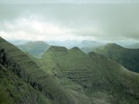
One of the most arresting sights in
the Scottish Highlands - the sheer walls of Toll a Mhadaidh Mhor, the
great corrie on the southeast side of Beinn Alligin. Sgurr Mor,
Alligin's principal summit, fills the shot to the right and the great
cleft of the Eag Dubh is obvious. It's said that Britain's last wolf
was shot in this corrie, late in the eighteenth century.
|
|
From the same spot, Graham tracks
the camera down and to the right for a shot of Na Rathanan, the Horns
of Alligin. This is a route often described in guidebooks as "exciting"
or "challenging", a sure warning to faint-hearted hillwalkers
like me that it's a place to be avoided. In fact the general consensus
sems to be that the Horns exhibit roughly the same standard of
difficulty as Striding Edge on Helvellyn.
|

|
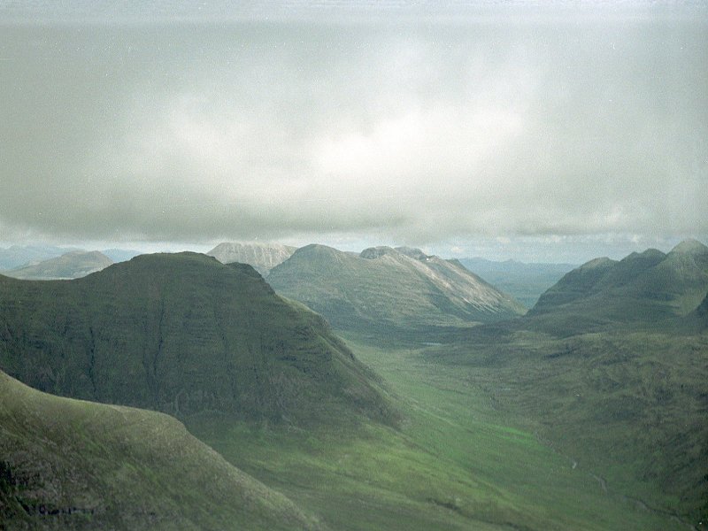
Further to the right again we're
looking down the length of the wild glen to the rear of Liathach. The
heel of the Horns is closest to us on the far left. with the dark blade
of Beinn Dearg next along, about two miles away. Beinn Dearg ("Red
Mountain") just fails to reach the magic figure of 3000 ft high. Beyond
Beinn Dearg, in the centre of shot, is the sandstone / quartzite
magnificence of Beinn Eighe. Liathach is coming into view on the right.
|

|
A fifth panorama shot from Tom na
Gruagaich shows Liathach in all its terrible splendour. Liathach is a
mountaineers' mountain, a peak that inspires awe, possibly the most
magnificent hill in Britain. The principal summit of Spidean a Choire
Leith is well seen, together with the chaotic sandstone cliffs on its
north side. Liathach's ridge walk is commonly regarded as the most
difficult on the UK mainland. You'll not be getting me up that one.
|

|
Tom na Gruagaich's summit trig
pillar. Curiously, there's no trig pillar on Sgurr Mor.
|
|
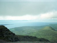
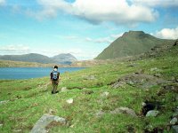
A look out to the west; that's Loch
Torridon out there, with the northern tip of the Isle of Skye beyond.
The pimple-shaped hill a couple of miles away is An Ruadh-mheallan.
|

|
A view a little to the south of the
previos shot, in which we see the northern tip of the Applecross
peninsula above Tom na Gruagaich's east top. Skye is in the distance,
with the isle of Rona between it and Applecross.
|
|
We had lunch on the top of Tom na
Gruagaich and it's relatively late, getting on for 2pm, as we set off
on the ridge walk to Sgurr Mor. Initially the terrain is benign, though
very stony.
|

|
We cast a look back at the way
we came.
|
|
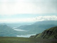
And, from the same spot, a view
across Upper Loch Torridon to the south, with Loch Damh seen beyond.
|
|
Graham put the camera away for the
next hour as we made our way along the ridge to Sgur Mor. It becomes
narrower and
rough, and one is continually distracted by the awesome cliffs of the Toll a Mhadaidh Mhor a few feet to the right. On
the way down to the col there is one awkward obstacle, a rockstep of
several feet that makes many think twice, but with care it can be
bypassed a little way to the left. The slopes are steep on this side
but nothing like as sheer as those to the right. It's quite a climb
again from the col, and we took a path bypassing the un-named middle
summit. From the second col there's a steep climb of about 500 feet to
the top of Sgurr Mor and I seriously considered leaving my rucksack
there to cut down the effort. It was just on 3pm when we arrived here -
the top of the magnificent vertical gash of Eag Dubh.
|

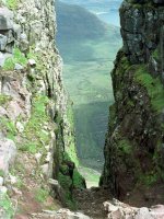
|
Eag Dubh fairly takes your breath
away. It goes straight down for 2000 feet. Even the top of it needs two
portrait shots to capture, the scale is just too big to get it into one
picture.
|
|
It was ten past three when we
arrived at Sgurr Mor, the principal summit of Beinn Alligin. It was
Graham's first Munro, and my third. A magnificent view over Upper Loch
Torridon was our first reward.
|

|
An awesome view of Liathach, now
free of cloud and seen in its magnificent entirety.
|

|
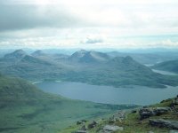
What could be better than this?
Torridon laid bare - the Horns of Alligin, backed by Beinn Dearg,
backed by Beinn Eighe. One of the finest views in Scotland.
|
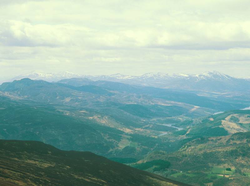
|
The magnificent wilderness of the
Flowerdale forest to the north of Beinn Dearg. Beiin an Eoin is about
five miles away, and beyond it across the unseen Loch Maree is Slioch.
|

|
I could easily over-use the word
"magnificent" here but what else does justice to this scene? The wild
northern hinterland of Beinn Alligin is seen here, with Loch Toll nam
Biast in the foreground and Loch a Bhealaich (at the foot of
Baosbheinn, out of shot) to the rear.
|

|
The unspoiled emptiness of the
Flowerdale forest to the rear of Beinn Dearg.
After spending some thirty minutes at the top of Beinn Alligin we felt
that time was pressing. We returned the way we'd come, down to the
first col, then descended the long, grassy slopes to the west. We were
aiming to go round the Horns to the rear.
|

|
We're a thousand feet lower down
here, and approaching Loch Toll nam
Biast and its nameless neighbour. The terrain had looked a bit scary
from up above. What were we letting ourselves in for?
|
|
About the only time you'll ever
see me in these galleries. We're making our way along the south shore
of Loch Toll nam Biast and are
pleasantly surprised by the benign nature of the terrain.
|

|
This is proving to be a real
adventure. What from above looked like it could be naked mud proved to
be a huge pavement of bare Torridonian sandstone. Mindful of the packed
contours at the eastern end of the Horms we're making sure to lose
height as rapidly as the terrain will allow, but we're completely taken
with this scene. Here is complete, true, wilderness - not a single
trace of the hand of man can be seen. No buildings, no roads or tracks,
no
plantations, no fences or walls, no paths, no power lines, no
footprints. Just pristine, empty country. And we have it all to
ourselves.
|

|
Baosbheinn, enjoying late afternoon
sunshine as we make our way across another rock pavement.
|

|
We made our way down the slopes by
the outflow from Loch Toll nam Biast
to arrive in the upper reaches of Bealach a Chomhla, between Beinn
Alligin and Beinn Dearg. It was a fairly easy walk to the south, with
traces of path here and there, before we picked up the well-used route
coming off the foot of the Horns. From here the path descended beside
the Allt a' Bhealach (stream of the pass) to cross the footbridge and
join the main path along the Coire Mhic Nobuil. The sun was shining
strongly and gave us this beautiful view along the glen towards Beinn
Eighe.
|

|
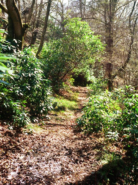
It was gone 7pm when we reached the
forest again, with only a short distance to cover back to the car. It
was a struggle to find somewhere still serving food at that time in the
evening but eventually we found ourselves a bar meal at the Shieldaig
Hotel. Sorry to use that word yet again, but we'd had a truly
magnificent day.
|


