 |
Burtness
Wood
The climb out from Buttermere village took this lovely route through Burtness wood on Buttermere's south shore. |
 |
Buttermere
The path reaches the thousand foot contour above the wood. Here we're looking back at Honister Pass across Buttermere. Fleetwith Pike is prominent to the right. |
 |
Crummock
Water
Looking northwest from the same spot along the length of Crummock Water to Lorton Vale beyond. Rannerdale Knotts rises to the right, Mellbreak to the left. |
 |
Buttermere
village
Looking back at the start of our climb, 900 ft below. Whiteless Pike stands on the other side of the village, with Grasmoor, Eel Crag and Sail beyond. Robinson is seen to the right. |
 |
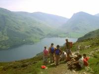
The
Mountain Goat group above Buttermere
Still one of my favourite shots after eighteen years - the group, with Tim the guide, halts at a bend in the path for a refreshment break. |
 |
Crummock
Water (2)
Crummock Water again, seen from the 1500ft contour. |
 |
Red
Pike ascent
The group nears the old drystone wall at Sour Milk Gill |
 |
Sour
Milk Gill
This lively little mountain stream, once recommended as an ascent route but now considered too dangerous, falls to Buttermere from the coombe between Red Pike and High Stile |
 |
Bleaberry
Tarn
Chapel Crags and White Pike look down on Bleaberry Tarn, where some members of our group stopped for a swim. At a height of 1600ft, the tarn is very cold even in high summer. |
 |
The
Saddle
The Saddle is the name of the col between Red Pike and its outlier, Dodd. We're at 2100ft and the climb from here to the summit of red Pike is steep and stony. |
 |
Red
Pike
Just east of the summit, looking towards White Pike (close at hand) and High Stile (half a mile distant) |
 |
White
Pike
A minor "top" of High Stile, White Pike gives this view of Bleaberry Tarn 700 ft below. |
 |
Chapel
Crags
Bleaberry Tarn is framed by the top of a gully in Chapel Crags, just west of the main summit |
 |
High
Stile
Red Pike and Bleaberry Tarn from the summit of High Stile (2644ft) |
 |
High
Stile (2)
The view southeast from the summit, looking towards the Scafells some five miles away. |
 |
High
Stile (3)
Looking down into Burtness Combe from the summit crags |